A node is one of the core elements in the OpenStreetMap data model. More...
#include <qgsosmbase.h>
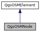
Inheritance diagram for QgsOSMNode:

Public Member Functions | |
| QgsOSMNode () | |
| QgsOSMNode (QgsOSMId id, const QgsPoint &point) | |
| QgsPoint | point () const |
 Public Member Functions inherited from QgsOSMElement Public Member Functions inherited from QgsOSMElement | |
| QgsOSMElement () | |
| QgsOSMElement (QgsOSMElementID::Type t, QgsOSMId id) | |
| QgsOSMElementID | elemID () const |
| QgsOSMId | id () const |
| bool | isValid () const |
Detailed Description
A node is one of the core elements in the OpenStreetMap data model.
It consists of a single geospatial point using a latitude and longitude. A third optional dimension, altitude, can be recorded; key:ele and a node can also be defined at a particular layer=* or level=*. Nodes can be used to define standalone point features or be used to define the path of a way.
Definition at line 70 of file qgsosmbase.h.
Constructor & Destructor Documentation
◆ QgsOSMNode() [1/2]
|
inline |
Definition at line 73 of file qgsosmbase.h.
◆ QgsOSMNode() [2/2]
Definition at line 74 of file qgsosmbase.h.
Member Function Documentation
◆ point()
|
inline |
Definition at line 79 of file qgsosmbase.h.
The documentation for this class was generated from the following file:
- /tmp/buildd/qgis-2.18.21+99unstable/src/analysis/openstreetmap/qgsosmbase.h
 1.8.13