QgsPointCloudLayerProfileGeneratorBase Class Referenceabstract
Base class for the point cloud elevation profile generators. More...
#include <qgspointcloudlayerprofilegenerator.h>
Inheritance diagram for QgsPointCloudLayerProfileGeneratorBase:
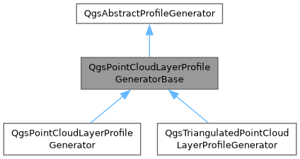
Public Member Functions | |
| QgsPointCloudLayerProfileGeneratorBase (QgsPointCloudLayer *layer, const QgsProfileRequest &request) | |
| Constructor for QgsPointCloudLayerProfileGeneratorBase. | |
| virtual | ~QgsPointCloudLayerProfileGeneratorBase () override |
| Public Member Functions inherited from QgsAbstractProfileGenerator | |
| virtual | ~QgsAbstractProfileGenerator () |
| virtual QgsFeedback * | feedback () const =0 |
Access to feedback object of the generator (may be nullptr). | |
| virtual Qgis::ProfileGeneratorFlags | flags () const |
| Returns flags which reflect how the profile generator operates. | |
| virtual bool | generateProfile (const QgsProfileGenerationContext &context=QgsProfileGenerationContext())=0 |
| Generate the profile (based on data stored in the class). | |
| virtual QString | sourceId () const =0 |
| Returns a unique identifier representing the source of the profile. | |
| virtual QgsAbstractProfileResults * | takeResults ()=0 |
| Takes results from the generator. | |
| virtual QString | type () const =0 |
| Returns the unique string identifier for the results type. | |
Protected Member Functions | |
| bool | collectData (QgsGeos &curve, const double mapUnitsPerPixel, const double maximumErrorPixels, const QgsDoubleRange &zRange, double &maxErrorInLayerCrs) |
| Collects point cloud data along a curve within the specified range and tolerance. | |
| void | gatherPoints (QgsPointCloudIndex &pc, QgsPointCloudRequest &request, double maxErrorPixels, double nodeErrorPixels, const QgsDoubleRange &zRange, const QgsRectangle &searchExtent) |
| Collects points from the point cloud index within the given extent and Z range. | |
| QVector< QgsPointCloudNodeId > | traverseTree (QgsPointCloudIndex &pc, QgsPointCloudNodeId n, double maxErrorPixels, double nodeErrorPixels, const QgsDoubleRange &zRange, const QgsRectangle &searchExtent) |
| Recursively traverses the point cloud node tree to gather visible nodes. | |
| virtual void | visitBlock (const QgsPointCloudBlock *block, const QgsDoubleRange &zRange)=0 |
| Visits a point cloud block and collects points within the given Z range and search geometry. | |
| int | visitNodesAsync (const QVector< QgsPointCloudNodeId > &nodes, QgsPointCloudIndex &pc, QgsPointCloudRequest &request, const QgsDoubleRange &zRange) |
| Asynchronously visits point cloud nodes, loading their data and processing valid blocks. | |
| int | visitNodesSync (const QVector< QgsPointCloudNodeId > &nodes, QgsPointCloudIndex &pc, QgsPointCloudRequest &request, const QgsDoubleRange &zRange) |
| Synchronously visits point cloud nodes and processes their data. | |
Protected Attributes | |
| std::unique_ptr< QgsFeedback > | mFeedback = nullptr |
| QString | mId |
| QgsPointCloudIndex | mIndex |
| QPointer< QgsPointCloudLayer > | mLayer |
| QgsPointCloudAttributeCollection | mLayerAttributes |
| QgsCoordinateTransform | mLayerToTargetTransform |
| double | mMaximumScreenError = 0.3 |
| Qgis::RenderUnit | mMaximumScreenErrorUnit = Qgis::RenderUnit::Millimeters |
| std::unique_ptr< QgsPreparedPointCloudRendererData > | mPreparedRendererData |
| std::unique_ptr< QgsCurve > | mProfileCurve |
| std::unique_ptr< QgsPointCloudRenderer > | mRenderer |
| std::unique_ptr< QgsGeos > | mSearchGeometryInLayerCrsGeometryEngine |
| QgsCoordinateReferenceSystem | mSourceCrs |
| double | mStepDistance = std::numeric_limits<double>::quiet_NaN() |
| const QVector< QgsPointCloudSubIndex > | mSubIndexes |
| QgsCoordinateReferenceSystem | mTargetCrs |
| double | mTolerance = 0 |
| QgsCoordinateTransformContext | mTransformContext |
| double | mZOffset = 0 |
| double | mZScale = 1.0 |
Detailed Description
Base class for the point cloud elevation profile generators.
- Note
- Not available in Python bindings
- Since
- QGIS 4.0
Definition at line 124 of file qgspointcloudlayerprofilegenerator.h.
Constructor & Destructor Documentation
◆ QgsPointCloudLayerProfileGeneratorBase()
| QgsPointCloudLayerProfileGeneratorBase::QgsPointCloudLayerProfileGeneratorBase | ( | QgsPointCloudLayer * | layer, |
| const QgsProfileRequest & | request ) |
Constructor for QgsPointCloudLayerProfileGeneratorBase.
Definition at line 346 of file qgspointcloudlayerprofilegenerator.cpp.
◆ ~QgsPointCloudLayerProfileGeneratorBase()
|
overridevirtualdefault |
Member Function Documentation
◆ collectData()
|
protected |
Collects point cloud data along a curve within the specified range and tolerance.
Prepares attribute requests and renderer data, then gathers points from relevant point cloud indexes. Updates the maximum allowable error in layer coordinates.
- Parameters
-
curve Search geometry. mapUnitsPerPixel Number of map units per pixel in the distance dimension. maximumErrorPixels Maximum permissible projected error in pixels. zRange Vertical range filter. maxErrorInLayerCrs Output parameter for the derived maximum error in layer CRS.
- Returns
- True on success, false if canceled or an error occurred.
Definition at line 369 of file qgspointcloudlayerprofilegenerator.cpp.
◆ gatherPoints()
|
protected |
Collects points from the point cloud index within the given extent and Z range.
Traverses the node tree to identify relevant nodes, then loads and processes them either synchronously or asynchronously depending on the access type.
- Parameters
-
pc Pint cloud index. request Point cloud data request item. maxErrorPixels Maximum allowed projected error in pixels. nodeErrorPixels Node's projected error in pixels. zRange Vertical range filter. searchExtent Search extent.
Definition at line 610 of file qgspointcloudlayerprofilegenerator.cpp.
◆ traverseTree()
|
protected |
Recursively traverses the point cloud node tree to gather visible nodes.
Filters nodes based on Z range, spatial intersection with the search extent, and screen-space error threshold. Returns all nodes that meet the criteria and contain points.
- Parameters
-
pc Point cloud index. n Node ID to evaluate. maxErrorPixels Maximum allowed projected error in pixels. nodeErrorPixels Node's projected error in pixels. zRange Vertical range filter. searchExtent Search extent.
- Returns
- List of nodes that satisfy the given constraints.
Definition at line 488 of file qgspointcloudlayerprofilegenerator.cpp.
◆ visitBlock()
|
protectedpure virtual |
Visits a point cloud block and collects points within the given Z range and search geometry.
Extracts point coordinates from the block, optionally filters them using the renderer, handled reprojection if needed and adds the valid points to results.
- Parameters
-
block Point cloud block to process. zRange Vertical range to include points within.
◆ visitNodesAsync()
|
protected |
Asynchronously visits point cloud nodes, loading their data and processing valid blocks.
Requests node data asynchronously, waits for completion and calls visitBlock() for each successfully loaded block within the specified Z range.
- Parameters
-
nodes List of nodes to process. pc Point cloud index. request Point cloud data request item. zRange Vertical range for filtering points.
- Returns
- Number of successfully processed nodes.
Definition at line 547 of file qgspointcloudlayerprofilegenerator.cpp.
◆ visitNodesSync()
|
protected |
Synchronously visits point cloud nodes and processes their data.
Loads each node’s block data sequentially, calls visitBlock() for valid blocks within the given Z range.
- Parameters
-
nodes Nodes to process. pc Point cloud index. request Point cloud data request item. zRange Vertical range for filtering points.
- Returns
- Number of successfully processed nodes.
Definition at line 527 of file qgspointcloudlayerprofilegenerator.cpp.
Member Data Documentation
◆ mFeedback
|
protected |
Definition at line 232 of file qgspointcloudlayerprofilegenerator.h.
◆ mId
|
protected |
Definition at line 230 of file qgspointcloudlayerprofilegenerator.h.
◆ mIndex
|
protected |
Definition at line 222 of file qgspointcloudlayerprofilegenerator.h.
◆ mLayer
|
protected |
Definition at line 221 of file qgspointcloudlayerprofilegenerator.h.
◆ mLayerAttributes
|
protected |
Definition at line 224 of file qgspointcloudlayerprofilegenerator.h.
◆ mLayerToTargetTransform
|
protected |
Definition at line 245 of file qgspointcloudlayerprofilegenerator.h.
◆ mMaximumScreenError
|
protected |
Definition at line 227 of file qgspointcloudlayerprofilegenerator.h.
◆ mMaximumScreenErrorUnit
|
protected |
Definition at line 228 of file qgspointcloudlayerprofilegenerator.h.
◆ mPreparedRendererData
|
protected |
Definition at line 248 of file qgspointcloudlayerprofilegenerator.h.
◆ mProfileCurve
|
protected |
Definition at line 246 of file qgspointcloudlayerprofilegenerator.h.
◆ mRenderer
|
protected |
Definition at line 225 of file qgspointcloudlayerprofilegenerator.h.
◆ mSearchGeometryInLayerCrsGeometryEngine
|
protected |
Definition at line 249 of file qgspointcloudlayerprofilegenerator.h.
◆ mSourceCrs
|
protected |
Definition at line 236 of file qgspointcloudlayerprofilegenerator.h.
◆ mStepDistance
|
protected |
Definition at line 240 of file qgspointcloudlayerprofilegenerator.h.
◆ mSubIndexes
|
protected |
Definition at line 223 of file qgspointcloudlayerprofilegenerator.h.
◆ mTargetCrs
|
protected |
Definition at line 237 of file qgspointcloudlayerprofilegenerator.h.
◆ mTolerance
|
protected |
Definition at line 234 of file qgspointcloudlayerprofilegenerator.h.
◆ mTransformContext
|
protected |
Definition at line 238 of file qgspointcloudlayerprofilegenerator.h.
◆ mZOffset
|
protected |
Definition at line 242 of file qgspointcloudlayerprofilegenerator.h.
◆ mZScale
|
protected |
Definition at line 243 of file qgspointcloudlayerprofilegenerator.h.
The documentation for this class was generated from the following files:
- /build/qgis-4.3.0+git20261026+16eddb2670e+99sid/src/core/pointcloud/qgspointcloudlayerprofilegenerator.h
- /build/qgis-4.3.0+git20261026+16eddb2670e+99sid/src/core/pointcloud/qgspointcloudlayerprofilegenerator.cpp
Generated on for QGIS API Documentation by
 1.17.0