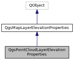
Point cloud layer specific subclass of QgsMapLayerElevationProperties. More...
#include <qgspointcloudlayerelevationproperties.h>

Public Member Functions | |
| QgsPointCloudLayerElevationProperties (QObject *parent) | |
| Constructor for QgsPointCloudLayerElevationProperties, with the specified parent object. More... | |
| QgsDoubleRange | calculateZRange (QgsMapLayer *layer) const override |
| Attempts to calculate the overall elevation or z range for the specified layer, using the settings defined by this elevation properties object. More... | |
| bool | hasElevation () const override |
Returns true if the layer has an elevation or z component. More... | |
| bool | isVisibleInZRange (const QgsDoubleRange &range) const override |
Returns true if the layer should be visible and rendered for the specified z range. More... | |
| bool | readXml (const QDomElement &element, const QgsReadWriteContext &context) override |
| Reads the elevation properties from a DOM element previously written by writeXml(). More... | |
| void | setZOffset (double offset) |
| Sets the z offset, which is a fixed offset amount which will be added to z values from the layer. More... | |
| void | setZScale (double scale) |
| Sets the z scale, which is a scaling factor which will be applied to z values from the layer. More... | |
| QDomElement | writeXml (QDomElement &element, QDomDocument &doc, const QgsReadWriteContext &context) override |
| Writes the properties to a DOM element, to be used later with readXml(). More... | |
| double | zOffset () const |
| Returns the z offset, which is a fixed offset amount which should be added to z values from the layer. More... | |
| double | zScale () const |
| Returns the z scale, which is a scaling factor which should be applied to z values from the layer. More... | |
 Public Member Functions inherited from QgsMapLayerElevationProperties Public Member Functions inherited from QgsMapLayerElevationProperties | |
| QgsMapLayerElevationProperties (QObject *parent) | |
| Constructor for QgsMapLayerElevationProperties, with the specified parent object. More... | |
| virtual QgsMapLayerElevationProperties::Flags | flags () const |
| Returns flags associated to the elevation properties. More... | |
Additional Inherited Members | |
 Public Types inherited from QgsMapLayerElevationProperties Public Types inherited from QgsMapLayerElevationProperties | |
| enum | Flag { FlagDontInvalidateCachedRendersWhenRangeChanges = 1 } |
| Flags attached to the elevation property. More... | |
 Signals inherited from QgsMapLayerElevationProperties Signals inherited from QgsMapLayerElevationProperties | |
| void | changed () |
| Emitted when the elevation properties have changed. More... | |
Detailed Description
Point cloud layer specific subclass of QgsMapLayerElevationProperties.
- Since
- QGIS 3.18
Definition at line 33 of file qgspointcloudlayerelevationproperties.h.
Constructor & Destructor Documentation
◆ QgsPointCloudLayerElevationProperties()
| QgsPointCloudLayerElevationProperties::QgsPointCloudLayerElevationProperties | ( | QObject * | parent | ) |
Constructor for QgsPointCloudLayerElevationProperties, with the specified parent object.
Definition at line 21 of file qgspointcloudlayerelevationproperties.cpp.
Member Function Documentation
◆ calculateZRange()
|
overridevirtual |
Attempts to calculate the overall elevation or z range for the specified layer, using the settings defined by this elevation properties object.
May return an infinite range if the extent could not be calculated.
Reimplemented from QgsMapLayerElevationProperties.
Definition at line 54 of file qgspointcloudlayerelevationproperties.cpp.
◆ hasElevation()
|
overridevirtual |
Returns true if the layer has an elevation or z component.
Reimplemented from QgsMapLayerElevationProperties.
Definition at line 26 of file qgspointcloudlayerelevationproperties.cpp.
◆ isVisibleInZRange()
|
overridevirtual |
Returns true if the layer should be visible and rendered for the specified z range.
Reimplemented from QgsMapLayerElevationProperties.
Definition at line 48 of file qgspointcloudlayerelevationproperties.cpp.
◆ readXml()
|
overridevirtual |
Reads the elevation properties from a DOM element previously written by writeXml().
- See also
- writeXml()
Implements QgsMapLayerElevationProperties.
Definition at line 40 of file qgspointcloudlayerelevationproperties.cpp.
◆ setZOffset()
|
inline |
Sets the z offset, which is a fixed offset amount which will be added to z values from the layer.
This can be used to correct or manually adjust for incorrect elevation values in a point cloud layer.
- See also
- zOffset()
Definition at line 73 of file qgspointcloudlayerelevationproperties.h.
◆ setZScale()
|
inline |
Sets the z scale, which is a scaling factor which will be applied to z values from the layer.
This can be used to correct or manually adjust for incorrect elevation values in a point cloud layer, such as conversion of elevation values in feet to meters.
- See also
- zScale()
Definition at line 99 of file qgspointcloudlayerelevationproperties.h.
◆ writeXml()
|
overridevirtual |
Writes the properties to a DOM element, to be used later with readXml().
- See also
- readXml()
Implements QgsMapLayerElevationProperties.
Definition at line 31 of file qgspointcloudlayerelevationproperties.cpp.
◆ zOffset()
|
inline |
Returns the z offset, which is a fixed offset amount which should be added to z values from the layer.
This can be used to correct or manually adjust for incorrect elevation values in a point cloud layer.
- See also
- setZOffset()
Definition at line 61 of file qgspointcloudlayerelevationproperties.h.
◆ zScale()
|
inline |
Returns the z scale, which is a scaling factor which should be applied to z values from the layer.
This can be used to correct or manually adjust for incorrect elevation values in a point cloud layer, such as conversion of elevation values in feet to meters.
- See also
- setZScale()
Definition at line 86 of file qgspointcloudlayerelevationproperties.h.
The documentation for this class was generated from the following files:
- /build/qgis-3.20.0+99unstable/src/core/pointcloud/qgspointcloudlayerelevationproperties.h
- /build/qgis-3.20.0+99unstable/src/core/pointcloud/qgspointcloudlayerelevationproperties.cpp