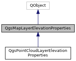
Base class for storage of map layer elevation properties. More...
#include <qgsmaplayerelevationproperties.h>

Public Types | |
| enum | Flag { FlagDontInvalidateCachedRendersWhenRangeChanges = 1 } |
| Flags attached to the elevation property. More... | |
Signals | |
| void | changed () |
| Emitted when the elevation properties have changed. More... | |
Public Member Functions | |
| QgsMapLayerElevationProperties (QObject *parent) | |
| Constructor for QgsMapLayerElevationProperties, with the specified parent object. More... | |
| virtual QgsDoubleRange | calculateZRange (QgsMapLayer *layer) const |
| Attempts to calculate the overall elevation or z range for the specified layer, using the settings defined by this elevation properties object. More... | |
| virtual QgsMapLayerElevationProperties::Flags | flags () const |
| Returns flags associated to the elevation properties. More... | |
| virtual bool | hasElevation () const |
Returns true if the layer has an elevation or z component. More... | |
| virtual bool | isVisibleInZRange (const QgsDoubleRange &range) const |
Returns true if the layer should be visible and rendered for the specified z range. More... | |
| virtual bool | readXml (const QDomElement &element, const QgsReadWriteContext &context)=0 |
| Reads the elevation properties from a DOM element previously written by writeXml(). More... | |
| virtual QDomElement | writeXml (QDomElement &element, QDomDocument &doc, const QgsReadWriteContext &context)=0 |
| Writes the properties to a DOM element, to be used later with readXml(). More... | |
Detailed Description
Base class for storage of map layer elevation properties.
QgsMapLayerElevationProperties exposes user-configurable settings for controlling how an individual QgsMapLayer behaves with relation to z values or elevations.
- Since
- QGIS 3.18
Definition at line 40 of file qgsmaplayerelevationproperties.h.
Member Enumeration Documentation
◆ Flag
Flags attached to the elevation property.
| Enumerator | |
|---|---|
| FlagDontInvalidateCachedRendersWhenRangeChanges | Any cached rendering will not be invalidated when z range context is modified. |
Definition at line 66 of file qgsmaplayerelevationproperties.h.
Constructor & Destructor Documentation
◆ QgsMapLayerElevationProperties()
| QgsMapLayerElevationProperties::QgsMapLayerElevationProperties | ( | QObject * | parent | ) |
Constructor for QgsMapLayerElevationProperties, with the specified parent object.
Definition at line 20 of file qgsmaplayerelevationproperties.cpp.
Member Function Documentation
◆ calculateZRange()
|
virtual |
Attempts to calculate the overall elevation or z range for the specified layer, using the settings defined by this elevation properties object.
May return an infinite range if the extent could not be calculated.
Reimplemented in QgsPointCloudLayerElevationProperties.
Definition at line 35 of file qgsmaplayerelevationproperties.cpp.
◆ changed
|
signal |
Emitted when the elevation properties have changed.
◆ flags()
|
inlinevirtual |
Returns flags associated to the elevation properties.
Definition at line 104 of file qgsmaplayerelevationproperties.h.
◆ hasElevation()
|
virtual |
Returns true if the layer has an elevation or z component.
Reimplemented in QgsPointCloudLayerElevationProperties.
Definition at line 25 of file qgsmaplayerelevationproperties.cpp.
◆ isVisibleInZRange()
|
virtual |
Returns true if the layer should be visible and rendered for the specified z range.
Reimplemented in QgsPointCloudLayerElevationProperties.
Definition at line 30 of file qgsmaplayerelevationproperties.cpp.
◆ readXml()
|
pure virtual |
Reads the elevation properties from a DOM element previously written by writeXml().
- See also
- writeXml()
Implemented in QgsPointCloudLayerElevationProperties.
◆ writeXml()
|
pure virtual |
Writes the properties to a DOM element, to be used later with readXml().
- See also
- readXml()
Implemented in QgsPointCloudLayerElevationProperties.
The documentation for this class was generated from the following files:
- /build/qgis-3.20.0+99unstable/src/core/qgsmaplayerelevationproperties.h
- /build/qgis-3.20.0+99unstable/src/core/qgsmaplayerelevationproperties.cpp