|
QGIS API Documentation
2.4.0-Chugiak
|


All Classes Namespaces Files Functions Variables Typedefs Enumerations Enumerator Properties Friends Macros Groups Pages
|
QGIS API Documentation
2.4.0-Chugiak
|
Map tool for identifying features in layers. More...
#include <qgsmaptoolidentify.h>
Classes | |
| struct | IdentifyResult |
Public Types | |
| enum | IdentifyMode { DefaultQgsSetting = -1, ActiveLayer, TopDownStopAtFirst, TopDownAll, LayerSelection } |
| enum | LayerType { AllLayers = -1, VectorLayer, RasterLayer } |
Public Slots | |
| void | formatChanged (QgsRasterLayer *layer) |
| void | layerDestroyed () |
Signals | |
| void | identifyProgress (int, int) |
| void | identifyMessage (QString) |
| void | changedRasterResults (QList< IdentifyResult > &) |
 Signals inherited from QgsMapTool Signals inherited from QgsMapTool | |
| void | messageEmitted (QString message, QgsMessageBar::MessageLevel=QgsMessageBar::INFO) |
| emit a message More... | |
| void | messageDiscarded () |
| emit signal to clear previous message More... | |
Public Member Functions | |
| QgsMapToolIdentify (QgsMapCanvas *canvas) | |
| constructor More... | |
| virtual | ~QgsMapToolIdentify () |
| virtual void | canvasMoveEvent (QMouseEvent *e) |
| Overridden mouse move event. More... | |
| virtual void | canvasPressEvent (QMouseEvent *e) |
| Overridden mouse press event. More... | |
| virtual void | canvasReleaseEvent (QMouseEvent *e) |
| Overridden mouse release event. More... | |
| virtual void | activate () |
| called when set as currently active map tool More... | |
| virtual void | deactivate () |
| called when map tool is being deactivated More... | |
| QList< IdentifyResult > | identify (int x, int y, QList< QgsMapLayer * > layerList=QList< QgsMapLayer * >(), IdentifyMode mode=DefaultQgsSetting) |
| Performs the identification. More... | |
| QList< IdentifyResult > | identify (int x, int y, IdentifyMode mode, LayerType layerType=AllLayers) |
| Performs the identification. More... | |
| Public Member Functions inherited from QgsMapTool | |
| virtual | ~QgsMapTool () |
| virtual destructor More... | |
| virtual void | canvasDoubleClickEvent (QMouseEvent *e) |
| Mouse double click event for overriding. Default implementation does nothing. More... | |
| virtual void | wheelEvent (QWheelEvent *e) |
| Mouse wheel event for overriding. More... | |
| virtual void | keyPressEvent (QKeyEvent *e) |
| Key event for overriding. Default implementation does nothing. More... | |
| virtual void | keyReleaseEvent (QKeyEvent *e) |
| Key event for overriding. More... | |
| virtual Q_DECL_DEPRECATED void | renderComplete () |
| Called when rendering has finished. More... | |
| void | setAction (QAction *action) |
| Use this to associate a QAction to this maptool. More... | |
| QAction * | action () |
| Return associated action with map tool or NULL if no action is associated. More... | |
| void | setButton (QAbstractButton *button) |
| Use this to associate a button to this maptool. More... | |
| QAbstractButton * | button () |
| Return associated button with map tool or NULL if no button is associated. More... | |
| virtual void | setCursor (QCursor cursor) |
| Set a user defined cursor. More... | |
| virtual bool | isTransient () |
| Check whether this MapTool performs a zoom or pan operation. More... | |
| virtual bool | isEditTool () |
| Check whether this MapTool performs an edit operation. More... | |
| QgsMapCanvas * | canvas () |
| returns pointer to the tool's map canvas More... | |
| QString | toolName () |
| Emit map tool changed with the old tool. More... | |
Protected Member Functions | |
| void | deleteRubberBands () |
| rubber bands for layer select mode More... | |
| Protected Member Functions inherited from QgsMapTool | |
| QgsMapTool (QgsMapCanvas *canvas) | |
| constructor takes map canvas as a parameter More... | |
| QgsPoint | toMapCoordinates (const QPoint &point) |
| transformation from screen coordinates to map coordinates More... | |
| QgsPoint | toLayerCoordinates (QgsMapLayer *layer, const QPoint &point) |
| transformation from screen coordinates to layer's coordinates More... | |
| QgsPoint | toLayerCoordinates (QgsMapLayer *layer, const QgsPoint &point) |
| transformation from map coordinates to layer's coordinates More... | |
| QgsPoint | toMapCoordinates (QgsMapLayer *layer, const QgsPoint &point) |
| transformation from layer's coordinates to map coordinates (which is different in case reprojection is used) More... | |
| QgsRectangle | toLayerCoordinates (QgsMapLayer *layer, const QgsRectangle &rect) |
| trnasformation of the rect from map coordinates to layer's coordinates More... | |
| QPoint | toCanvasCoordinates (const QgsPoint &point) |
| transformation from map coordinates to screen coordinates More... | |
Private Slots | |
| void | handleMenuHover () |
| menu for layer selection More... | |
Private Member Functions | |
| QList< IdentifyResult > | identify (int x, int y, IdentifyMode mode, QList< QgsMapLayer * > layerList, LayerType layerType=AllLayers) |
| Performs the identification. More... | |
| bool | identifyLayer (QList< IdentifyResult > *results, QgsMapLayer *layer, QgsPoint point, QgsRectangle viewExtent, double mapUnitsPerPixel, LayerType layerType=AllLayers) |
| call the right method depending on layer type More... | |
| bool | identifyRasterLayer (QList< IdentifyResult > *results, QgsRasterLayer *layer, QgsPoint point, QgsRectangle viewExtent, double mapUnitsPerPixel) |
| bool | identifyVectorLayer (QList< IdentifyResult > *results, QgsVectorLayer *layer, QgsPoint point) |
| virtual void | convertMeasurement (QgsDistanceArea &calc, double &measure, QGis::UnitType &u, bool isArea) |
| Private helper. More... | |
| virtual QGis::UnitType | displayUnits () |
| Transforms the measurements of derived attributes in the desired units. More... | |
| QMap< QString, QString > | featureDerivedAttributes (QgsFeature *feature, QgsMapLayer *layer) |
Private Attributes | |
| QMap< QgsMapLayer *, QList < IdentifyResult > > | mLayerIdResults |
| layer id map for layer select mode More... | |
| QList< QgsHighlight * > | mRubberBands |
| rubber bands for layer select mode More... | |
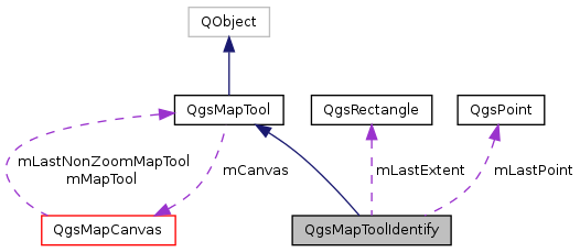
| QgsPoint | mLastPoint |
| double | mLastMapUnitsPerPixel |
| QgsRectangle | mLastExtent |
Additional Inherited Members | |
| Static Public Member Functions inherited from QgsMapTool | |
| static double | searchRadiusMM () |
| Get search radius in mm. More... | |
| static double | searchRadiusMU (const QgsRenderContext &context) |
| Get search radius in map units for given context. More... | |
| static double | searchRadiusMU (QgsMapCanvas *canvas) |
| Get search radius in map units for given canvas. More... | |
| Protected Attributes inherited from QgsMapTool | |
| QgsMapCanvas * | mCanvas |
| pointer to map canvas More... | |
| QCursor | mCursor |
| cursor used in map tool More... | |
| QAction * | mAction |
| optionally map tool can have pointer to action which will be used to set that action as active More... | |
| QAbstractButton * | mButton |
| optionally map tool can have pointer to a button which will be used to set that action as active More... | |
| QString | mToolName |
| translated name of the map tool More... | |
Map tool for identifying features in layers.
after selecting a point, performs the identification:
Definition at line 44 of file qgsmaptoolidentify.h.
| Enumerator | |
|---|---|
| DefaultQgsSetting | |
| ActiveLayer | |
| TopDownStopAtFirst | |
| TopDownAll | |
| LayerSelection | |
Definition at line 50 of file qgsmaptoolidentify.h.
| Enumerator | |
|---|---|
| AllLayers | |
| VectorLayer | |
| RasterLayer | |
Definition at line 59 of file qgsmaptoolidentify.h.
| QgsMapToolIdentify::QgsMapToolIdentify | ( | QgsMapCanvas * | canvas | ) |
constructor
Definition at line 48 of file qgsmaptoolidentify.cpp.
References identify_cursor, and QgsMapTool::mCursor.
|
virtual |
Definition at line 56 of file qgsmaptoolidentify.cpp.
|
virtual |
called when set as currently active map tool
Reimplemented from QgsMapTool.
Definition at line 243 of file qgsmaptoolidentify.cpp.
References QgsMapTool::activate().
|
virtual |
Overridden mouse move event.
Reimplemented from QgsMapTool.
Definition at line 60 of file qgsmaptoolidentify.cpp.
|
virtual |
Overridden mouse press event.
Reimplemented from QgsMapTool.
Definition at line 65 of file qgsmaptoolidentify.cpp.
|
virtual |
Overridden mouse release event.
Reimplemented from QgsMapTool.
Definition at line 70 of file qgsmaptoolidentify.cpp.
|
signal |
Referenced by formatChanged().
|
privatevirtual |
Private helper.
Definition at line 623 of file qgsmaptoolidentify.cpp.
References QgsDistanceArea::convertMeasurement(), displayUnits(), QgsMapCanvas::mapUnits(), and QgsMapTool::mCanvas.
Referenced by featureDerivedAttributes().
|
virtual |
called when map tool is being deactivated
Reimplemented from QgsMapTool.
Definition at line 248 of file qgsmaptoolidentify.cpp.
References QgsMapTool::deactivate().
|
protected |
rubber bands for layer select mode
Definition at line 698 of file qgsmaptoolidentify.cpp.
References mRubberBands.
Referenced by handleMenuHover(), and identify().
|
privatevirtual |
Transforms the measurements of derived attributes in the desired units.
Definition at line 635 of file qgsmaptoolidentify.cpp.
References QgsMapCanvas::mapUnits(), and QgsMapTool::mCanvas.
Referenced by convertMeasurement().
|
private |
Definition at line 359 of file qgsmaptoolidentify.cpp.
References QgsGeometry::asPoint(), QgsGeometry::asPolyline(), convertMeasurement(), QgsMapLayer::crs(), GEO_NONE, QgsFeature::geometry(), QgsMapCanvas::hasCrsTransformEnabled(), QgsProject::instance(), QgsMapSettings::layerToMapCoordinates(), QGis::Line, QgsMapCanvas::mapSettings(), QgsMapTool::mCanvas, QgsDistanceArea::measure(), QgsDistanceArea::measurePerimeter(), QGis::NoGeometry, QGis::Point, QGis::Polygon, QgsProject::readEntry(), QgsDistanceArea::setEllipsoid(), QgsDistanceArea::setEllipsoidalMode(), QgsDistanceArea::setSourceCrs(), QgsCoordinateReferenceSystem::srsid(), QgsDistanceArea::textUnit(), QgsPoint::toString(), tr, QgsGeometry::type(), QGis::WKBLineString, QGis::WKBLineString25D, QGis::WKBNoGeometry, QGis::WKBPoint, QGis::WKBPoint25D, QgsGeometry::wkbType(), QgsPoint::x(), and QgsPoint::y().
Referenced by identifyRasterLayer(), and identifyVectorLayer().
|
slot |
Definition at line 640 of file qgsmaptoolidentify.cpp.
References changedRasterResults(), identifyRasterLayer(), mLastExtent, mLastMapUnitsPerPixel, mLastPoint, and QgsDebugMsg.
|
privateslot |
menu for layer selection
Definition at line 650 of file qgsmaptoolidentify.cpp.
References deleteRubberBands(), QgsMapLayerRegistry::instance(), layerDestroyed(), QgsMapLayerRegistry::mapLayer(), QgsMapTool::mCanvas, mLayerIdResults, mRubberBands, QgsHighlight::setColor(), and QgsHighlight::setWidth().
Referenced by identify().
| QList< QgsMapToolIdentify::IdentifyResult > QgsMapToolIdentify::identify | ( | int | x, |
| int | y, | ||
| QList< QgsMapLayer * > | layerList = QList<QgsMapLayer*>(), |
||
| IdentifyMode | mode = DefaultQgsSetting |
||
| ) |
Performs the identification.
| x | x coordinates of mouseEvent |
| y | y coordinates of mouseEvent |
| layerList | Performs the identification within the given list of layers. Default value is an empty list, i.e. uses all the layers. |
| mode | Identification mode. Can use Qgis default settings or a defined mode. Default mode is DefaultQgsSetting. |
Definition at line 75 of file qgsmaptoolidentify.cpp.
References AllLayers.
Referenced by identify().
| QList< QgsMapToolIdentify::IdentifyResult > QgsMapToolIdentify::identify | ( | int | x, |
| int | y, | ||
| IdentifyMode | mode, | ||
| LayerType | layerType = AllLayers |
||
| ) |
Performs the identification.
To avoid beeing forced to specify IdentifyMode with a list of layers this has been made private and two publics methods are offered
| x | x coordinates of mouseEvent |
| y | y coordinates of mouseEvent |
| mode | Identification mode. Can use Qgis default settings or a defined mode. |
| layerType | Only performs identification in a certain type of layers (raster, vector). Default value is AllLayers. |
Definition at line 80 of file qgsmaptoolidentify.cpp.
References identify().
|
private |
Performs the identification.
To avoid beeing forced to specify IdentifyMode with a list of layers this has been made private and two publics methods are offered
| x | x coordinates of mouseEvent |
| y | y coordinates of mouseEvent |
| mode | Identification mode. Can use Qgis default settings or a defined mode. |
| layerList | Performs the identification within the given list of layers. |
| layerType | Only performs identification in a certain type of layers (raster, vector). |
Definition at line 85 of file qgsmaptoolidentify.cpp.
References QgsMapTool::action(), ActiveLayer, QgsMapCanvas::currentLayer(), DefaultQgsSetting, deleteRubberBands(), QgsMapCanvas::extent(), QgsVectorLayer::geometryType(), QgsMapCanvas::getCoordinateTransform(), QgsApplication::getThemeIcon(), handleMenuHover(), QgsMapLayer::id(), identify(), identifyLayer(), identifyMessage(), identifyProgress(), QgsMapLayerRegistry::instance(), QgsProject::instance(), QgsMapCanvas::layer(), QgsMapCanvas::layerCount(), LayerSelection, QGis::Line, QgsMapLayerRegistry::mapLayer(), QgsMapCanvas::mapUnitsPerPixel(), QgsMapTool::mCanvas, mLastExtent, mLastMapUnitsPerPixel, mLastPoint, mLayerIdResults, QgsMapLayer::name(), QGis::Point, QGis::Polygon, QgsMapLayer::RasterLayer, QgsProject::readListEntry(), QgsMapToPixel::toMapCoordinates(), TopDownAll, TopDownStopAtFirst, and tr.
|
private |
call the right method depending on layer type
Definition at line 253 of file qgsmaptoolidentify.cpp.
References AllLayers, identifyRasterLayer(), identifyVectorLayer(), QgsMapLayer::RasterLayer, RasterLayer, QgsMapLayer::type(), QgsMapLayer::VectorLayer, and VectorLayer.
Referenced by identify().
|
signal |
Referenced by identify().
|
signal |
Referenced by identify().
|
private |
Definition at line 429 of file qgsmaptoolidentify.cpp.
References QgsRasterInterface::capabilities(), QgsRectangle::contains(), QgsDataProvider::crs(), QgsMapLayer::customProperty(), QgsRasterLayer::dataProvider(), QgsMapSettings::destinationCrs(), QgsRasterIdentifyResult::error(), QgsMapLayer::extent(), featureDerivedAttributes(), QgsFeatureStore::features(), QgsFeatureStore::fields(), QgsRasterInterface::generateBandName(), QgsMapCanvas::hasCrsTransformEnabled(), QgsRectangle::height(), QgsRasterInterface::Identify, QgsRasterDataProvider::identify(), QgsRasterInterface::IdentifyFeature, QgsRaster::IdentifyFormatFeature, QgsRasterDataProvider::identifyFormatFromName(), QgsRaster::IdentifyFormatHtml, QgsRaster::IdentifyFormatText, QgsRasterDataProvider::identifyFormatToCapability(), QgsRaster::IdentifyFormatValue, QgsRasterInterface::IdentifyHtml, QgsRasterInterface::IdentifyText, QgsRasterInterface::IdentifyValue, QgsRasterIdentifyResult::isValid(), QgsMapCanvas::mapSettings(), QgsMapTool::mCanvas, QgsError::message(), QgsRasterIdentifyResult::mParams, QgsMapLayer::name(), QgsFeatureStore::params(), QgsRasterBlock::printValue(), QgsDebugMsg, QgsRasterIdentifyResult::results(), QgsRectangle::setXMaximum(), QgsRectangle::setXMinimum(), QgsRectangle::setYMaximum(), QgsRectangle::setYMinimum(), QgsRasterLayer::subLayers(), QgsErrorMessage::Text, QgsMapTool::toLayerCoordinates(), QgsPoint::toString(), tr, QgsException::what(), QgsRectangle::width(), QgsPoint::x(), and QgsPoint::y().
Referenced by formatChanged(), and identifyLayer().
|
private |
Definition at line 269 of file qgsmaptoolidentify.cpp.
References QgsFeatureRendererV2::capabilities(), QgsFeatureRequest::ExactIntersect, featureDerivedAttributes(), FID_TO_STRING, QgsFeatureRendererV2::Filter, QgsRenderContext::fromMapSettings(), QgsVectorLayer::getFeatures(), QgsVectorLayer::hasGeometryType(), QgsMapLayer::hasScaleBasedVisibility(), QgsMapCanvas::mapSettings(), QgsMapLayer::maximumScale(), QgsMapTool::mCanvas, QgsMapLayer::minimumScale(), QgsFeatureIterator::nextFeature(), QgsVectorLayer::pendingFields(), QgsDebugMsg, QgsVectorLayer::rendererV2(), QgsMapSettings::scale(), QgsFeatureRendererV2::ScaleDependent, QgsMapTool::searchRadiusMU(), QgsRectangle::setXMaximum(), QgsRectangle::setXMinimum(), QgsRectangle::setYMaximum(), QgsRectangle::setYMinimum(), QgsFeatureRendererV2::startRender(), QgsFeatureRendererV2::stopRender(), QgsMapTool::toLayerCoordinates(), QgsPoint::toString(), tr, QgsException::what(), QgsFeatureRendererV2::willRenderFeature(), QgsPoint::x(), and QgsPoint::y().
Referenced by identifyLayer().
|
slot |
Definition at line 706 of file qgsmaptoolidentify.cpp.
References mRubberBands.
Referenced by handleMenuHover().
|
private |
Definition at line 174 of file qgsmaptoolidentify.h.
Referenced by formatChanged(), and identify().
|
private |
Definition at line 172 of file qgsmaptoolidentify.h.
Referenced by formatChanged(), and identify().
|
private |
Definition at line 170 of file qgsmaptoolidentify.h.
Referenced by formatChanged(), and identify().
|
private |
layer id map for layer select mode
Definition at line 165 of file qgsmaptoolidentify.h.
Referenced by handleMenuHover(), and identify().
|
private |
rubber bands for layer select mode
Definition at line 167 of file qgsmaptoolidentify.h.
Referenced by deleteRubberBands(), handleMenuHover(), and layerDestroyed().
 1.8.7
1.8.7