.
QGIS Configuration
QGIS is highly configurable through the Settings menu. Choose between Panels, Toolbars, Project Properties, Options and Customization.
Примечание
QGIS follows desktop guidelines for the location of options and project properties item. Consequently related to the OS you are using, location of some of items described above could be located in the View menu (Panels and Toolbars) or in Project for Options.
Panels and Toolbars
In the Panels‣ menu, you can switch on and off QGIS widgets. The Toolbars‣ menu provides the possibility to switch on and off icon groups in the QGIS toolbar (see figure_panels_toolbars).
Figure Panels and Toolbars:
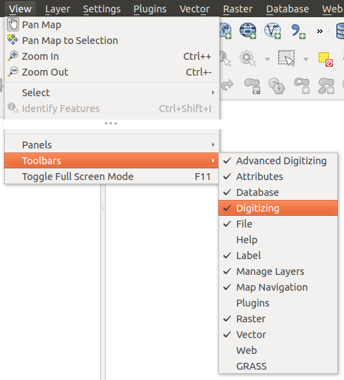
The Panels and Toolbars menu 
Совет
Activating the QGIS Overview
In QGIS, you can use an overview panel that provides a full extent view of
layers added to it. It can be selected under the menu Settings ‣ Panels or
 View ‣ Panels. Within the view is a rectangle showing the
current map extent. This allows you to quickly determine which area of the
map you are currently viewing. Note that labels are not rendered to the map
overview even if the layers in the map overview have been set up for
labeling. If you click and drag the red rectangle in the overview that shows
your current extent, the main map view will update accordingly.
View ‣ Panels. Within the view is a rectangle showing the
current map extent. This allows you to quickly determine which area of the
map you are currently viewing. Note that labels are not rendered to the map
overview even if the layers in the map overview have been set up for
labeling. If you click and drag the red rectangle in the overview that shows
your current extent, the main map view will update accordingly.
Совет
Show Log Messages
It’s possible to track the QGIS messages. You can activate
 Log Messages in the menu
Settings ‣ Panels or
View ‣ Panels and follow the messages
that appear in the different tabs during loading and operation.
Log Messages in the menu
Settings ‣ Panels or
View ‣ Panels and follow the messages
that appear in the different tabs during loading and operation.
Свойства проекта
In the properties window for the project under
Settings ‣ Project Properties (kde) or
Project ‣ Project Properties (Gnome), you can set
project-specific options. These include:
- In the General menu, the project title, selection and background color, layer units, precision, and the option to save relative paths to layers can be defined. If the CRS transformation is on, you can choose an ellipsoid for distance calculations. You can define the canvas units (only used when CRS transformation is disabled) and the precision of decimal places to use. You can also define a project scale list, which overrides the global predefined scales.
Вкладка Система координат позволяет выбрать систему координат для данного проекта и включить преобразование координат векторных и растровых слоёв «на лету», если используются слои с разными системами координат.
- With the third Identify layers menu, you set (or disable) which layers will respond to the identify tool (see the “Map tools” paragraph from the Параметры section to enable identifying of multiple layers).
- The Default Styles menu lets you control how new layers will be drawn when they do not have an existing .qml style defined. You can also set the default transparency level for new layers and whether symbols should have random colours assigned to them. There is also an additional section where you can define specific colors for the running project. You can find the added colors in the drop down menu of the color dialog window present in each renderer.
- The tab OWS Server allows you to define information about the QGIS Server WMS and WFS capabilities, extent and CRS restrictions.
- The Macros menu is used to edit Python macros for projects. Currently, only three macros are available: openProject(), saveProject() and closeProject().
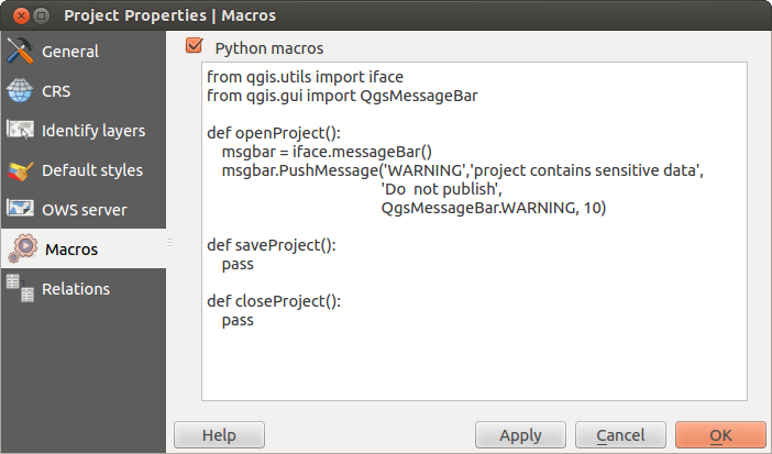
Macro settings in QGIS
- The Relations menu is used to define 1:n relations. The relations are defined in the project properties dialog. Once relations exist for a layer, a new user interface element in the form view (e.g. when identifying a feature and opening its form) will list the related entities. This provides a powerful way to express e.g. the inspection history on a length of pipeline or road segment. You can find out more about 1:n relations support in Section Creating one to many relations.
Параметры
 Some basic options for QGIS can be selected using the
Options dialog. Select the menu option Settings ‣
Options. The tabs where you can customize your
options are described below.
Some basic options for QGIS can be selected using the
Options dialog. Select the menu option Settings ‣
Options. The tabs where you can customize your
options are described below.
Владка «Общи延
Приложение
- Select the Style (QGIS restart required)
 and choose
between ‘Oxygen’,’Windows’,’Motif’,’CDE’, ‘Plastique’ and ‘Cleanlooks’ ().
and choose
between ‘Oxygen’,’Windows’,’Motif’,’CDE’, ‘Plastique’ and ‘Cleanlooks’ (). - Define the Icon theme . Currently only ‘default’ is
possible.
- Define the Icon size .
- Define the Font. Choose between
 Qt default and a user-defined font.
 - Change the Timeout for timed messages or dialogs .
- Не показывать заставку при запуске
- Показывать совет дня при запуске
- Выделять заголовки групп виджетов
- Оформлять группы виджетов в стиле QGIS
- Use native color chooser dialogs
- Use live-updating color chooser dialogs
- Custom side bar style
- Experimental canvas rotation support (restart required)
Файлы проектов
- Open project on launch (choose between ‘New’,
‘Most recent’ and ‘Specific’). When choosing ‘Specific’ use the
 to define a project.
 - Create new project from default project. You have the
possibility to press on Set current project as default or on
Reset default. You can browse through your files and define a
directory where you find your user-defined project templates. This will be
added to Project ‣ New From Template. If you first activate
Create new project from default project and then save
a project in the project templates folder.
- Запрашивать сохранение изменений в проекте и источниках данных, когда это необходимо
- Prompt for confirmation when a layer is to be removed
- Warn when opening a project file saved with an older
version of QGIS
- Enable macros . This option was created to handle
macros that are written to perform an action on project events. You can
choose between ‘Never’, ‘Ask’, ‘For this session only’ and
‘Always (not recommended)’.
Вкладка «Систем໶
Переменные среды
System environment variables can now be viewed, and many configured, in the Environment group (see figure_environment_variables). This is useful for platforms, such as Mac, where a GUI application does not necessarily inherit the user’s shell environment. It’s also useful for setting and viewing environment variables for the external tool sets controlled by the Processing toolbox (e.g., SAGA, GRASS), and for turning on debugging output for specific sections of the source code.
- Use custom variables (restart required - include separators).
You can [Add] and [Remove] variables. Already-defined environment
variables are displayed in Current environment variables, and it’s
possible to filter them by activating
Show only QGIS-specific variables.
Figure System Environment:
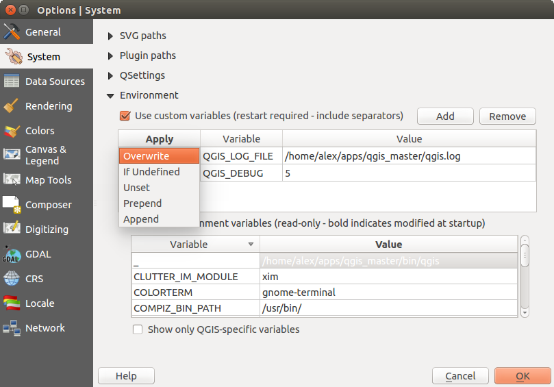
System environment variables in QGIS
Модули
[Add] or [Remove] Path(s) to search for additional C++ plugin libraries
Вкладка «Источники данных»
Таблица атрибутов
- Открывать таблицу аттрибутов во встраиваемом окне (требуется перезапуск)
- Copy geometry in WKT representation from attribute
table. When using
 Copy selected rows to
clipboard from the Attribute table dialog, this has the
result that the coordinates of points or vertices are also copied to the
clipboard.
Copy selected rows to
clipboard from the Attribute table dialog, this has the
result that the coordinates of points or vertices are also copied to the
clipboard. - Attribute table behaviour . There are three
possibilities: ‘Show all features’, ‘Show selected features’ and ‘Show
features visible on map’.
- Attribute table row cache
 . This row cache makes
it possible to save the last loaded N attribute rows so that working with the
attribute table will be quicker. The cache will be deleted when closing the
attribute table.
. This row cache makes
it possible to save the last loaded N attribute rows so that working with the
attribute table will be quicker. The cache will be deleted when closing the
attribute table. - Representation for NULL values. Here, you can define a value for data fields containing a NULL value.
Источники данных
- Scan for valid items in the browser dock . You can
choose between ‘Check extension’ and ‘Check file contents’.
- Scan for contents of compressed files (.zip) in browser dock
. ‘No’, ‘Basic scan’ and ‘Full scan’ are possible.
- Prompt for raster sublayers when opening. Some rasters support
sublayers — they are called subdatasets in GDAL. An example is netCDF files
— if there are many netCDF variables, GDAL sees every variable as a
subdataset. The option allows you to control how to deal with sublayers when a file
with sublayers is opened. You have the following choices:
- ‘Always’: Always ask (if there are existing sublayers)
- ‘If needed’: Ask if layer has no bands, but has sublayers
- ‘Never’: Never prompt, will not load anything
- ‘Load all’: Never prompt, but load all sublayers
- Ignore shapefile encoding declaration. If a shapefile
has encoding information, this will be ignored by QGIS.
- Add PostGIS layers with double click and select in
extended mode
- Добавлять слои Oracle двойным щелчком и включить расширенную выборку
Вкладка «Отрисовк໶
Rendering behaviour
- By default new layers added to the map should be displayed
- Use render caching where possible to speed up redraws
- Render layers in parallel using many CPU cores
- Max cores to use
- Map update interval (default to 250 ms)
- Enable feature simplication by default for newly added layers
- Simplification threshold
- Simplify on provider side if possible
- Maximum scale at which the layer should be simplified
Параметры отрисовки
- Рисовать сглаженные линии (снижает скорость отрисовки)
Растры
- With RGB band selection, you can define the number for the Red, Green and Blue band.
Contrast enhancement
- Single band gray . A single band gray can have
‘No stretch’, ‘Stretch to MinMax’, ‘Stretch and Clip to MinMax’ and also
‘Clip to MinMax’.
- Multi band color (byte/band) . Options are ‘No stretch’,
‘Stretch to MinMax’, ‘Stretch and Clip to MinMax’ and ‘Clip to MinMax’.
- Multi band color (>byte/band) . Options are ‘No stretch’,
‘Stretch to MinMax’, ‘Stretch and Clip to MinMax’ and ‘Clip to MinMax’.
- Limits (minimum/maximum) . Options are
‘Cumulative pixel count cut’, ‘Minimum/Maximum’, ‘Mean +/- standard deviation’.
Границы среза с накоплением
Множитель стандартного отклонения
Отладка
- Map canvas refresh
Вкладка «Карта и легенд໶
Внешний вид по умолчанию
Установить Цвет выделения
 и Цвет фона .
Легенда
- Double click action in legend . You can either
‘Open layer properties’ or ‘Open attribute table’ with the double click.
- The following Legend item styles are possible:
- Выводить имена слоёв с прописной буквы
- Выделять слои полужирным шрифтом
- Выделять группы полужирным шрифтом
- Показывать в легенде атрибуты классификации
- Создавать значки для растровых слоёв
Вкладка «Инструменты»
This menu offers some options regarding the behaviour of the Identify tool.
- Search radius for identifying and displaying map tips is a tolerance factor expressed as a percentage of the map width. This means the identify tool will depict results as long as you click within this tolerance.
- Highlight color allows you to choose with which color should features being identified are to be highlighted.
- Buffer expressed as a percentage of the map width, determines a buffer distance to be rendered from the outline of the identify highlight.
- Minimum width expressed as a percentage of the map width, determines how thick should the outline of a highlighted object be.
Инструмент измерений
Установить Цвет линии для инструментов измерений
Установить число Десятичных знаков
- Keep base unit
- Preferred measurements units (‘Meters’, ‘Feet’, ‘Nautical Miles’ or ‘Degrees’)`
- Preferred angle units (‘Degrees’, ‘Radians’ or ‘Gon’)
Прокрутка и масштабирование
- Define Mouse wheel action (‘Zoom’, ‘Zoom and recenter’,
‘Zoom to mouse cursor’, ‘Nothing’)
Установить Фактор увеличения для колеса мыши
Масштабный ряд
Here, you find a list of predefined scales. With the [+] and [-] buttons you can add or remove your individual scales.
Composer Menu
Composition defaults
You can define the Default font here.
Grid appearance
- Define the Grid style (‘Solid’, ‘Dots’, ‘Crosses’)
- Define the Grid color
Grid and guide defaults
- Define the Grid spacing
- Define the Grid offset for x and y
- Define the Snap tolerance
Вкладка «Оцифровк໶
Создание объектов
- Отключить всплывающее окно ввода атрибутов для каждого создаваемого объекта
- Использовать последние введённые значения
- Validate geometries. Editing complex lines and polygons with many nodes can result in very slow rendering. This is because the default validation procedures in QGIS can take a lot of time. To speed up rendering, it is possible to select GEOS geometry validation (starting from GEOS 3.3) or to switch it off. GEOS geometry validation is much faster, but the disadvantage is that only the first geometry problem will be reported.
Резиновая нить
Установить Толщину линии
и Цвет линии для «резиновой нити»
Прилипание
- Открывать параметры прилипания во встраиваемом окне (требуется перезапуск)
- Define Default snap mode (‘To vertex’, ‘To segment’,
‘To vertex and segment’, ‘Off’)
Установить Порог прилипания по умолчанию в единицах карты или пикселях
Установить Радиус поиска для редактирования вершин
(в единицах карты или пикселях)
Маркеры вершин
- Показывать маркеры только для выбранных объектов
- Define vertex Marker style (‘Cross’ (default), ‘Semi
transparent circle’ or ‘None’)
Задать Размер маркера
.
Параллельные кривые
The next 3 options refer to the  Offset Curve tool
in Дополнительные функции оцифровки. Through the various settings, it is possible to
influence the shape of the line offset. These options are possible starting from GEOS 3.3.
Offset Curve tool
in Дополнительные функции оцифровки. Through the various settings, it is possible to
influence the shape of the line offset. These options are possible starting from GEOS 3.3.
- Join style
- Quadrant segments
- Miter limit
Вкладка «Система координат»
Система координат для новых проектов
 Don’t enable ‘on the fly’ reprojection
- Automatically enable ‘on the fly’ reprojection if
layers have different CRS
- Enable ‘on the fly’ reprojection by default
Создавать новые проекты в указанной системе координат
Система координат для новых слоёв
This area allows you to define the action to take when a new layer is created, or when a layer without a CRS is loaded.
- Prompt for CRS
- Use project CRS
- Use default CRS
Default datum transformations
- Ask for datum transformation when no default is defined
- If you have worked with the ‘on-the-fly’ CRS transformation you can see the result of the transformation in the window below. You can find information about ‘Source CRS’ and ‘Destination CRS’ as well as ‘Source datum transform’ and ‘Destination datum transform’.
Locale Menu
- Переопределить системный язык и Язык, используемый вместо системного
Дополнительная информация о системном языке
Network Menu
Общие
Задать Адрес поиска WMS-серверов,по умолчанию используется http://geopole.org/wms/search?search=\%1\&type=rss
Установить Таймаут для сетевых запросов (мс). Значение по умолчанию — 60000
Настроить Время актуальности данных WMS-C/WMTS по умолчанию (часы). Значение по умолчанию —- 24 часа.
- Define Max retry in case of tile request errors
- Define User-Agent
Figure Network Tab:
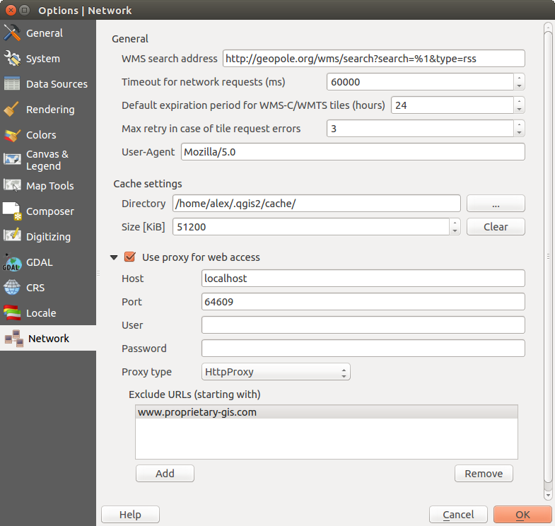
Proxy-settings in QGIS
Параметры кэширования
Задать Каталог и Размер кэша.
- Использовать прокси-сервер для внешних соединений и настроить поля «Узел», «Порт», «Пользователь», и «Пароль».
- Set the Proxy type according to your needs.
Default Proxy: прокси определяется настройками приложения
Socks5Proxy: Общий прокси для любого вида связи. Поддерживаются TCP, UDP, привязка к порту (входящие соединения) и авторизация
HttpProxy: реализован с использованием команды «СONNECT», поддерживает только исходящие TCP соединения; поддерживает авторизацию
- HttpCachingProxy: Implemented using normal HTTP commands, it is useful only in the context of HTTP requests.
- FtpCachingProxy: Implemented using an FTP proxy, it is useful only in the context of FTP requests.
Excluding some URLs can be added to the text box below the proxy settings (see Figure_Network_Tab).
If you need more detailed information about the different proxy settings, please refer to the manual of the underlying QT library documentation at http://doc.trolltech.com/4.5/qnetworkproxy.html#ProxyType-enum.
Совет
Использование прокси-серверов
Using proxies can sometimes be tricky. It is useful to proceed by ‘trial and error’ with the above proxy types, to check to see if they succeed in your case.
You can modify the options according to your needs. Some of the changes may require a restart of QGIS before they will be effective.
- Settings are saved in a text file: $HOME/.config/QGIS/QGIS2.conf
 You can find your settings in: $HOME/Library/Preferences/org.qgis.qgis.plist
- Settings are stored in the registry under: HKEY\CURRENT_USER\Software\QGIS\qgis
Настройка интерфейса
The customization tool lets you (de)activate almost every element in the QGIS user interface. This can be very useful if you have a lot of plugins installed that you never use and that are filling your screen.
Figure Customization 1:
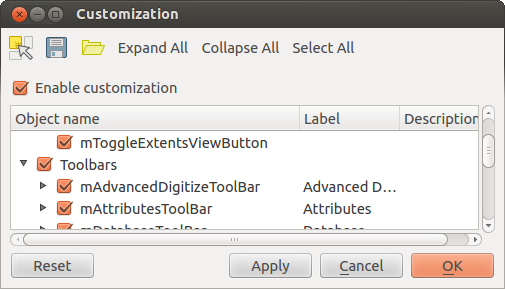
The Customization dialog
QGIS Customization is divided into five groups. In Menus,
you can hide entries in the Menu bar. In Panels, you
find the panel windows. Panel windows are applications that can be started and
used as a floating, top-level window or embedded to the QGIS main window as a
docked widget (see also Panels and Toolbars). In the
Status Bar, features like the coordinate information can be
deactivated. In Toolbars, you can (de)activate the
toolbar icons of QGIS, and in Widgets, you can (de)activate
dialogs as well as their buttons.
With  Switch to catching widgets in main application, you
can click on elements in QGIS that you want to be hidden and find the corresponding
entry in Customization (see figure_customization). You can also save your
various setups for different use cases as well. Before your changes
are applied, you need to restart QGIS.
Switch to catching widgets in main application, you
can click on elements in QGIS that you want to be hidden and find the corresponding
entry in Customization (see figure_customization). You can also save your
various setups for different use cases as well. Before your changes
are applied, you need to restart QGIS.