.
QGIS Configuration
QGIS is highly configurable through the Settings menu. Choose between Panels, Toolbars, Project Properties, Options and Customization.
Catatan
QGIS follows desktop guidelines for the location of options and project properties item. Consequently related to the OS you are using, location of some of items described above could be located in the View menu (Panels and Toolbars) or in Project for Options.
Panels and Toolbars
In the Panels‣ menu, you can switch on and off QGIS widgets. The Toolbars‣ menu provides the possibility to switch on and off icon groups in the QGIS toolbar (see figure_panels_toolbars).
Figure Panels and Toolbars:
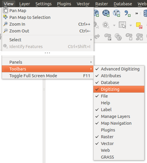
The Panels and Toolbars menu 
Tip
Activating the QGIS Overview
In QGIS, you can use an overview panel that provides a full extent view of
layers added to it. It can be selected under the menu Settings ‣ Panels or
 View ‣ Panels. Within the view is a rectangle showing the
current map extent. This allows you to quickly determine which area of the
map you are currently viewing. Note that labels are not rendered to the map
overview even if the layers in the map overview have been set up for
labeling. If you click and drag the red rectangle in the overview that shows
your current extent, the main map view will update accordingly.
View ‣ Panels. Within the view is a rectangle showing the
current map extent. This allows you to quickly determine which area of the
map you are currently viewing. Note that labels are not rendered to the map
overview even if the layers in the map overview have been set up for
labeling. If you click and drag the red rectangle in the overview that shows
your current extent, the main map view will update accordingly.
Tip
Show Log Messages
It’s possible to track the QGIS messages. You can activate
 Log Messages in the menu
Settings ‣ Panels or
View ‣ Panels and follow the messages
that appear in the different tabs during loading and operation.
Log Messages in the menu
Settings ‣ Panels or
View ‣ Panels and follow the messages
that appear in the different tabs during loading and operation.
Properti Proyek
In the properties window for the project under
Settings ‣ Project Properties (kde) or
Project ‣ Project Properties (Gnome), you can set
project-specific options. These include:
- In the General menu, the project title, selection and background color, layer units, precision, and the option to save relative paths to layers can be defined. If the CRS transformation is on, you can choose an ellipsoid for distance calculations. You can define the canvas units (only used when CRS transformation is disabled) and the precision of decimal places to use. You can also define a project scale list, which overrides the global predefined scales.
Menu CRS memungkinkan Anda untuk memilih Coordinat Reference System untuk proyek ini, dan memungkinkan proyeksi ulang on-the-fly lapisan raster dan lapisan vektor ketika menampilkan lapisan dari CRS yang berbeda.
- With the third Identify layers menu, you set (or disable) which layers will respond to the identify tool (see the “Map tools” paragraph from the Opsi section to enable identifying of multiple layers).
- The Default Styles menu lets you control how new layers will be drawn when they do not have an existing .qml style defined. You can also set the default transparency level for new layers and whether symbols should have random colours assigned to them. There is also an additional section where you can define specific colors for the running project. You can find the added colors in the drop down menu of the color dialog window present in each renderer.
- The tab OWS Server allows you to define information about the QGIS Server WMS and WFS capabilities, extent and CRS restrictions.
Menu Macros digunakan untuk mengedit Python macros untuk proyek. Saat ini, hanya tiga macro yang tersedia: openProject(), saveProject() dan closeProject().
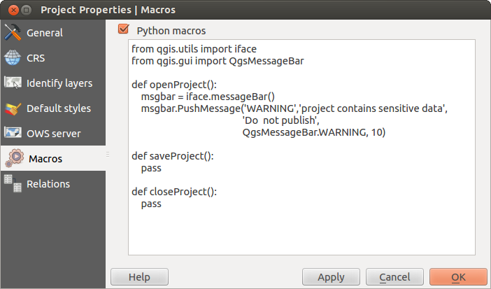
Macro settings in QGIS
Menu Relasi digunakan untuk menentukan relasi 1:n. Relasi ditentukan dalam dialog properti proyek. Setelah ada relasi lapisan, elemen antarmuka pengguna baru form tampilan (misalnya ketika mengidentifikasi fitur dan membuka form) akan daftar entitas terkait. Ini menyediakan cara ampuh mengekspresikan misalnya sejarah inspeksi pada panjang pipa atau segmen jalan. Anda bisa menemukan lebih jauh tentang relasi 1:n di Bagian Creating one to many relations.
Opsi
 Some basic options for QGIS can be selected using the
Options dialog. Select the menu option Settings ‣
Options. The tabs where you can customize your
options are described below.
Some basic options for QGIS can be selected using the
Options dialog. Select the menu option Settings ‣
Options. The tabs where you can customize your
options are described below.
Menu Umum
Aplikasi
- Select the Style (QGIS restart required)
 and choose
between ‘Oxygen’,’Windows’,’Motif’,’CDE’, ‘Plastique’ and ‘Cleanlooks’ ().
and choose
between ‘Oxygen’,’Windows’,’Motif’,’CDE’, ‘Plastique’ and ‘Cleanlooks’ (). - Define the Icon theme . Currently only ‘default’ is
possible.
- Define the Icon size .
- Define the Font. Choose between
 Qt default and a user-defined font.
 - Change the Timeout for timed messages or dialogs .
- Sembunyikan layar splash saat startup
- Tampilkan Petunjuk saat startup
- Judul tebal kotak grup
- QGIS-styled kotak grup
- Use native color chooser dialogs
- Use live-updating color chooser dialogs
- Custom side bar style
- Experimental canvas rotation support (restart required)
Berkas proyek
- Open project on launch (choose between ‘New’,
‘Most recent’ and ‘Specific’). When choosing ‘Specific’ use the
 to define a project.
 - Buat proyek baru dari proyek default. Anda memiliki kemungkinan untuk menekan Atur proyek sekarang sebagai default atau pada Reset default. Anda dapat menelusuri melalui berkas-berkas dan menentukan direktori dimana Anda menemukan pengguna-ditetapkan proyek template Anda. Akan ada sebuah entri di Project ‣ Baru dari Template jika Anda pertama kali mengaktifkan Buat proyek baru dari proyek default dan kemudian simpan proyek dalam folder proyek template.
- Prompt untuk menyimpan proyek dan sumber data perubahan bila diperlukan
- Prompt for confirmation when a layer is to be removed
- Peringatkan ketika membuka berkas proyek QGIS yang disimpan dengan versi lama
- Enable macros . This option was created to handle
macros that are written to perform an action on project events. You can
choose between ‘Never’, ‘Ask’, ‘For this session only’ and
‘Always (not recommended)’.
Menu Sistem
Lingkungan
Sistem lingkungan variabel saat ini dapat dilihat dan banyak dikonfigurasi dalam menu Lingkungan (lihat figure_environment_variables). Hal ini berguna untuk platform, seperti Mac, di mana aplikasi GUI tidak selalu mewarisi lingkungan shell pengguna. Ini juga berguna untuk pengaturan / melihat lingkungan variabel untuk mengatur alat eksternal yang dikendalikan oleh pengolahan toolbox (seperti SAGA, GRASS), dan untuk menyalakan keluaran debugging untuk bagian tertentu dari kode sumber.
- Gunakan penyesuaian variabel (dibutuhkan restart - termasuk pemisah). Anda bisa [Tambah] dan [Hapus] variabel. Variabel lingkungan yang sudah ditetapkan akan ditampilkan dalam:guilabel:Variabel lingkungan sekarang, dan hal itu memungkinkan untuk menyaring mereka dengan mengaktifkan Tampilkan hanya variabel spesifik-QGIS.
Figure System Environment:
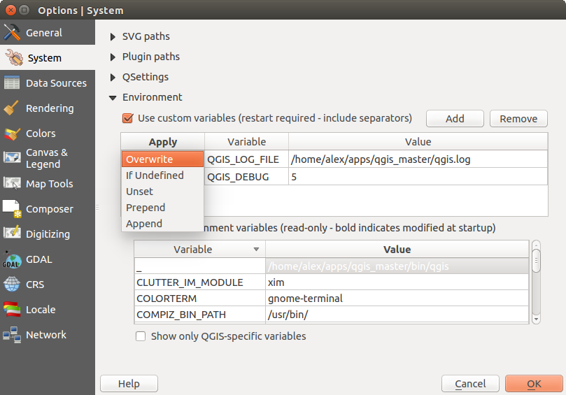
System environment variables in QGIS
Plugin path
[Tambah] atau [Hapus] Path(s) untuk mencari tambahan C++ librari Plugin
Menu sumber data
Atribut dan tabel fitur
- Buka tabel atribut di dock window (dibutuhkan restart QGIS)
- Copy geometry in WKT representation from attribute
table. When using
 Copy selected rows to
clipboard from the Attribute table dialog, this has the
result that the coordinates of points or vertices are also copied to the
clipboard.
Copy selected rows to
clipboard from the Attribute table dialog, this has the
result that the coordinates of points or vertices are also copied to the
clipboard. - Attribute table behaviour . There are three
possibilities: ‘Show all features’, ‘Show selected features’ and ‘Show
features visible on map’.
- Attribute table row cache
 . This row cache makes
it possible to save the last loaded N attribute rows so that working with the
attribute table will be quicker. The cache will be deleted when closing the
attribute table.
. This row cache makes
it possible to save the last loaded N attribute rows so that working with the
attribute table will be quicker. The cache will be deleted when closing the
attribute table. Representasi untuk nilai NULL Here you can define a value for data fields containing a NULL value. Di sini Anda dapat menentukan nilai untuk bidang data yang berisi nilai NULL.
Menangani sumber data
- Scan for valid items in the browser dock . You can
choose between ‘Check extension’ and ‘Check file contents’.
- Scan for contents of compressed files (.zip) in browser dock
. ‘No’, ‘Basic scan’ and ‘Full scan’ are possible.
Konfirmasi sublapisan raster saat membuka. Beberapa raster mendukung sublapisan – mereka disebut subdataset di GDAL. Contohnya adalah berkas netCDF - jika ada banyak variabel netCDF, GDAL melihat setiap variabel sebagai sub dataset. Pilihan ini untuk mengontrol bagaimana menangani sub-lapisan ketika sebuah berkas dengan sub-lapisan dibuka. Anda memiliki pilihan berikut:
‘Selalu’: Selalu bertanya (jika ada sub-lapisan yang ada)
‘Jika diperlukan’: Menanyakan apakah lapisan tidak memiliki band, namun memiliki sub-lapisan
‘Tidak Pernah’: Tidak pernah meminta, tidak akan memuat apa-apa
‘Muat semua’: Tidak pernah meminta, tetapi memuat semua sub-lapisan
- Ignore shapefile encoding declaration. If a shapefile
has encoding information, this will be ignored by QGIS.
- Add PostGIS layers with double click and select in
extended mode
- Tambahkan lapisan Oracle with dobel klik dan pilih dalam mode diperpanjang
Menu Rendering
Rendering behaviour
- Secara default lapisan baru yang ditambahkan ke peta harus ditampilkan
- Gunakan render caching yang memungkinkan mempercepat gambar ulang
- Render layers in parallel using many CPU cores
- Max cores to use
- Map update interval (default to 250 ms)
- Enable feature simplication by default for newly added layers
- Simplification threshold
- Sederhanakan di sisi penyedia jika mungkin
- Maximum scale at which the layer should be simplified
Kualitas rendering
- Membuat garis tampil kurang bagus dengan mengorbankan beberapa kinerja menggambar
Raster-raster
Dengan RGB band seleksi Anda bisa menetapkan nomor dari band Merah, Hijau dan Biru.
Contrast enhancement
- Single band gray . A single band gray can have
‘No stretch’, ‘Stretch to MinMax’, ‘Stretch and Clip to MinMax’ and also
‘Clip to MinMax’.
- Multi band color (byte/band) . Options are ‘No stretch’,
‘Stretch to MinMax’, ‘Stretch and Clip to MinMax’ and ‘Clip to MinMax’.
- Multi band color (>byte/band) . Options are ‘No stretch’,
‘Stretch to MinMax’, ‘Stretch and Clip to MinMax’ and ‘Clip to MinMax’.
- Limits (minimum/maximum) . Options are
‘Cumulative pixel count cut’, ‘Minimum/Maximum’, ‘Mean +/- standard deviation’.
Kumulatif batas jumlah potong pixel
Standar deviasi multiplier
Debugging
- Refresh kanvas peta
Menu Kanvas dan Legenda
Standar penampilan peta (diganti oleh proyek properti)
Tetapkan Seleksi warna dan Warna latar.
Legenda lapisan
- Double click action in legend . You can either
‘Open layer properties’ or ‘Open attribute table’ with the double click.
Mengikuti Gaya item legenda:
- Nama lapisan kapital
- Nama lapisan tebal
- Nama grup tebal
- Tampilkan klasifikasi nama atribut
- Buat ikon raster (mungkin lambat)
Menu perangkat Peta
This menu offers some options regarding the behaviour of the Identify tool.
- Search radius for identifying and displaying map tips is a tolerance factor expressed as a percentage of the map width. This means the identify tool will depict results as long as you click within this tolerance.
- Highlight color allows you to choose with which color should features being identified are to be highlighted.
- Buffer expressed as a percentage of the map width, determines a buffer distance to be rendered from the outline of the identify highlight.
- Minimum width expressed as a percentage of the map width, determines how thick should the outline of a highlighted object be.
Alat pengukuran
Tentukan Warna Rubberband untuk peralatan pengukuran
Tentukan Tempat desimal
- Keep base unit
- Preferred measurements units (‘Meters’, ‘Feet’, ‘Nautical Miles’ or ‘Degrees’)`
- Preferred angle units (‘Degrees’, ‘Radians’ or ‘Gon’)
Menggeser dan memperbesar
- Define Mouse wheel action (‘Zoom’, ‘Zoom and recenter’,
‘Zoom to mouse cursor’, ‘Nothing’)
Tentukan Faktor pembesaran untuk roda tetikus
Skala yang ditentukan
Here, you find a list of predefined scales. With the [+] and [-] buttons you can add or remove your individual scales.
Menu Penyusun
Standar Komposisi
You can define the Default font here.
Penampilan Kotak
- Define the Grid style (‘Solid’, ‘Dots’, ‘Crosses’)
- Define the Grid color
Grid and guide defaults
- Define the Grid spacing
- Define the Grid offset for x and y
- Define the Snap tolerance
Menu Digitalisasi
Membuat fitur
- Menekan atribut jendela pop-up setelah setiap fitur dibuat
- Gunakan kembali nilai atribut terakhir yang dimasukkan
- Validate geometries. Editing complex lines and polygons with many nodes can result in very slow rendering. This is because the default validation procedures in QGIS can take a lot of time. To speed up rendering, it is possible to select GEOS geometry validation (starting from GEOS 3.3) or to switch it off. GEOS geometry validation is much faster, but the disadvantage is that only the first geometry problem will be reported.
Rubberband
Tentukan Rubberband Lebar garis dan Warna garis
Snapping
- Buka opsi mengambil di dock window (dibutuhkan restart QGIS)
- Define Default snap mode (‘To vertex’, ‘To segment’,
‘To vertex and segment’, ‘Off’)
Tentukan Default toleransi snapping dalam satuan peta atau pixel
Tentukan Cari radius untuk suntingan simpul dalam satuan peta atau pixel
Penanda simpul
- Tampilkan penanda hanya untk fitur yang dipilih
- Define vertex Marker style (‘Cross’ (default), ‘Semi
transparent circle’ or ‘None’)
Tentukan simpul Ukuran Penanda
Alat ofset kurva
The next 3 options refer to the  Offset Curve tool
in Advanced digitizing. Through the various settings, it is possible to
influence the shape of the line offset. These options are possible starting from GEOS 3.3.
Offset Curve tool
in Advanced digitizing. Through the various settings, it is possible to
influence the shape of the line offset. These options are possible starting from GEOS 3.3.
Gaya Join
Segmen Quadrant
Batas Miter
Menu CRS
CRS standar untuk proyek baru
 Don’t enable ‘on the fly’ reprojection
- Automatically enable ‘on the fly’ reprojection if
layers have different CRS
- Enable ‘on the fly’ reprojection by default
Pilih sebuah CRS dan Selalui mulai proyek baru dengan CRS ini
CRS untuk lapisan baru
Daerah ini memungkinkan untuk menentukan tindakan ketika sebuah lapisan baru dibuat, atau ketika lapisan tanpa CRS dimuat.
- Prompt for CRS
- Use project CRS
- Use default CRS
Transformasi datum standar
- Mintalah transformasi datum bila tidak ada standar yang ditentukan
Jika Anda telah bekerja dengan transformasi CRS ‘on-the-fly’ Anda bisa melihat hasil dari transformasi dalam jendela di bawah. Anda bisa menemukan informasi tentang ‘Sumber CRS’ dan ‘Destinasi CRS’ maupun ‘Sumber datum transform’ dan ‘Destinasi datum transform’.
Menu Lokal
- Timpah sistem lokal dan Lokal gunakan sebagai pengganti
Informasi tentang sistem lokal aktif
Menu Jaringan
Umum
Tentukan WMS cari alamat, default http://geopole.org/wms/search?search=\%1\&type=rss
Tentukan Timeout untuk permintaan jaringan (ms) - default 60000
Tentukan Standar periode ekspirasi untuk WMSC/WMTS (jam) - default 24
Tentukan Mencoba kembali Maksimum jika terjadi kesalahan permintaan genteng
Tentukan User-Agent
Figure Network Tab:
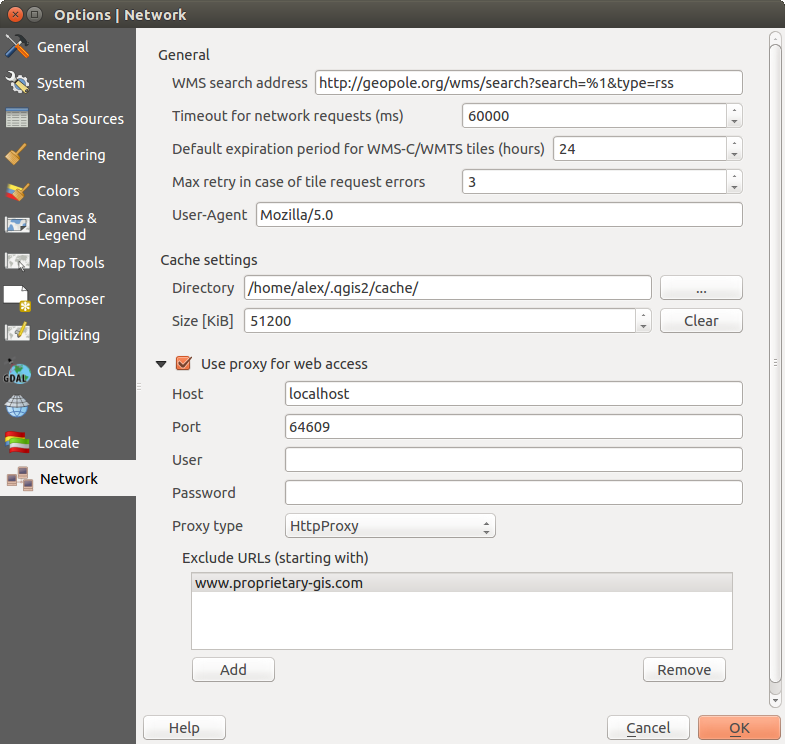
Proxy-settings in QGIS
Pengaturan cache
Tentukan Direktori dan Ukuran untuk cache.
- Gunakan proxy untuk akses web dan tentukan ‘Host’, ‘Port’, ‘Pengguna’, and ‘Kata Sandi’.
- Set the Proxy type according to your needs.
Proxy Standar: Proxy ditentukan berdasarkan aplikasi pengaturan menggunakan proxy
Socks5Proxy: Proxy generik untuk setiap jenis koneksi. Mendukung TCP, UDP, mengikat ke port (koneksi masuk) dan otentikasi.
HttpProxy: Menggunakan perintah “CONNECT”, mendukung hanya koneksi TCP; mendukung otentikasi.
HttpCachingProxy: Menggunakan perintah normal HTTP, itu hanya berguna dalam konteks permintaan HTTP.
FtpCachingProxy: Menggunakan proxy FTP, itu hanya berguna dalam konteks permintaan FTP.
Tidak termasuk beberapa URL dapat ditambahkan ke kotak teks di bawah pengaturan-proxy (lihat Figure_Network_Tab).
Jika Anda membutuhkan informasi lebih rinci tentang pengaturan-proxy yang berbeda, silakan lihat panduan QT-librari-dokumentasi di http://doc.trolltech.com/4.5/qnetworkproxy.html#ProxyType-enum.
Tip
Menggunakan Proxi
Menggunakan proxi kadang-kadang bisa rumit. Hal ini berguna ‘coba dan eror’ jenis proxi di atas, untuk memeriksa apakah mereka berhasil dalam kasus Anda.
You can modify the options according to your needs. Some of the changes may require a restart of QGIS before they will be effective.
- Settings are saved in a text file: $HOME/.config/QGIS/QGIS2.conf
 Anda dapat menemukan pengaturan Anda di: $HOME/Library/Preferences/org.qgis.qgis.plist
- pengaturan terkirim ke registri: HKEY\CURRENT_USER\Software\QGIS\qgis
Penyesuaian (Customization)
The customization tool lets you (de)activate almost every element in the QGIS user interface. This can be very useful if you have a lot of plugins installed that you never use and that are filling your screen.
Figure Customization 1:
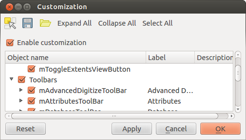
The Customization dialog
QGIS Customization is divided into five groups. In Menus,
you can hide entries in the Menu bar. In Panels, you
find the panel windows. Panel windows are applications that can be started and
used as a floating, top-level window or embedded to the QGIS main window as a
docked widget (see also Panels and Toolbars). In the
Status Bar, features like the coordinate information can be
deactivated. In Toolbars, you can (de)activate the
toolbar icons of QGIS, and in Widgets, you can (de)activate
dialogs as well as their buttons.
With  Switch to catching widgets in main application, you
can click on elements in QGIS that you want to be hidden and find the corresponding
entry in Customization (see figure_customization). You can also save your
various setups for different use cases as well. Before your changes
are applied, you need to restart QGIS.
Switch to catching widgets in main application, you
can click on elements in QGIS that you want to be hidden and find the corresponding
entry in Customization (see figure_customization). You can also save your
various setups for different use cases as well. Before your changes
are applied, you need to restart QGIS.