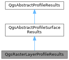
Implementation of QgsAbstractProfileResults for raster layers. More...
#include <qgsrasterlayerprofilegenerator.h>

Public Member Functions | |
| virtual QVector< QgsProfileIdentifyResults > | identify (const QgsDoubleRange &distanceRange, const QgsDoubleRange &elevationRange, const QgsProfileIdentifyContext &context) |
| Identify results visible within the specified ranges. | |
| QVector< QgsProfileIdentifyResults > | identify (const QgsProfilePoint &point, const QgsProfileIdentifyContext &context) override |
| Identify results visible at the specified profile point. | |
| QString | type () const override |
| Returns the unique string identifier for the results type. | |
| Public Member Functions inherited from QgsAbstractProfileSurfaceResults | |
| ~QgsAbstractProfileSurfaceResults () override | |
| QVector< QgsAbstractProfileResults::Feature > | asFeatures (Qgis::ProfileExportType type, QgsFeedback *feedback=nullptr) const override |
| Returns a list of features representing the calculated elevation results. | |
| QVector< QgsGeometry > | asGeometries () const override |
| Returns a list of geometries representing the calculated elevation results. | |
| void | copyPropertiesFromGenerator (const QgsAbstractProfileGenerator *generator) override |
| Copies properties from specified generator to the results object. | |
| QMap< double, double > | distanceToHeightMap () const override |
| Returns the map of distance (chainage) to height. | |
| void | renderResults (QgsProfileRenderContext &context) override |
| Renders the results to the specified context. | |
| QgsPointSequence | sampledPoints () const override |
| Returns a list of sampled points, with their calculated elevation as the point z value. | |
| QgsProfileSnapResult | snapPoint (const QgsProfilePoint &point, const QgsProfileSnapContext &context) override |
| Snaps a point to the generated elevation profile. | |
| QgsDoubleRange | zRange () const override |
| Returns the range of the retrieved elevation values. | |
| Public Member Functions inherited from QgsAbstractProfileResults | |
| virtual | ~QgsAbstractProfileResults () |
Friends | |
| class | QgsRasterLayerProfileGenerator |
Additional Inherited Members | |
| Public Attributes inherited from QgsAbstractProfileSurfaceResults | |
| double | maxZ = std::numeric_limits< double >::lowest() |
| QMap< double, double > | mDistanceToHeightMap |
| double | mElevationLimit = std::numeric_limits< double >::quiet_NaN() |
| std::unique_ptr< QgsFillSymbol > | mFillSymbol |
| QString | mId |
| double | minZ = std::numeric_limits< double >::max() |
| std::unique_ptr< QgsLineSymbol > | mLineSymbol |
| std::unique_ptr< QgsCurve > | mProfileCurve |
| QgsPointSequence | mRawPoints |
| Qgis::ProfileSurfaceSymbology | symbology = Qgis::ProfileSurfaceSymbology::Line |
Detailed Description
Implementation of QgsAbstractProfileResults for raster layers.
- Note
- Not available in Python bindings
- Since
- QGIS 3.26
Definition at line 45 of file qgsrasterlayerprofilegenerator.h.
Member Function Documentation
◆ identify() [1/2]
|
virtual |
Identify results visible within the specified ranges.
Reimplemented from QgsAbstractProfileSurfaceResults.
Definition at line 64 of file qgsabstractprofilegenerator.cpp.
◆ identify() [2/2]
|
overridevirtual |
Identify results visible at the specified profile point.
Reimplemented from QgsAbstractProfileSurfaceResults.
Definition at line 46 of file qgsrasterlayerprofilegenerator.cpp.
◆ type()
|
overridevirtual |
Returns the unique string identifier for the results type.
Implements QgsAbstractProfileResults.
Definition at line 41 of file qgsrasterlayerprofilegenerator.cpp.
Friends And Related Symbol Documentation
◆ QgsRasterLayerProfileGenerator
|
friend |
Definition at line 58 of file qgsrasterlayerprofilegenerator.h.
The documentation for this class was generated from the following files:
- /build/qgis-3.99.0+git20260209+8e76e220402+99sid/src/core/raster/qgsrasterlayerprofilegenerator.h
- /build/qgis-3.99.0+git20260209+8e76e220402+99sid/src/core/raster/qgsrasterlayerprofilegenerator.cpp
Generated on for QGIS API Documentation by